Access Guide
Introduction
- Related link Shopping in Worcester City.
- Http://www.visitworcestershire.org/worcester/Worcester-shopping.aspx
- Related link Worcester City Parking.
- Http://www.worcester.gov.uk/parking
Route Overview
- This route runs from the junction of Pump Street and High Street, in the pedestrianised city centre to the junction of The Shambles and St Swithin's Street.
- The route is pedestrianised throughout.
- Vehicular access to Pump Street and The Shambles is restricted to delivery vehicles and Blue Badge holders.
- The total length of this route is approximately 0.27km (0.17 miles).
- The average width of the pedestrianised section of this route is approximately 9m.
- This route is divided up into 2 sections in this guide:-
- 1. High Street to The Shambles.
- 2. Pump Street to St Swithin's Street.
- Pump Street and The Shambles are part of the main shopping area of the city centre.
- The pedestrianised parts of this route are closed to vehicles between 10:30 – 16.30 daily.
- Also pedestrianised but not forming part of this guide are High Street, Broad Street, Mealcheapen Street, The Shambles, Pump Street and Cathedral Square.
Getting Here
- Pump Street is located to the south end of the city centre.
- Pump Street is within the pedestrianised area of the city centre and is off High Street.
- Pump Street and The Shambles are pedestrianised streets joining other city centre streets, some of which are also pedestrianised.
- There are bus stops in Cathedral Square and on City Walls Road (A38).
- The nearest railway station is Worcester Foregate Street.
- There are no taxi ranks along this route.
Parking
- BLUE BADGE PARKING (2*)
- There are Blue Badge bays on Charles Street, off the east end of Pump Street.
- They are not marked into separate bays.
- There is room for up to 6 vehicles in the bay.
- The width of the bays is approximately 280cm.
- PUBLIC PARKING (1*)
- There are 2 public car parks with Blue Badge bays. Parking is not free for Blue Badge holders:-
- 1. NCP Cathedral Square Car Park, is located off Cathedral Square and Friar Street.
- 2. Cornmarket Car Park, located off Queen Street.
Access Guides Available For (Pump Street)
-
Shopping
View
- Cash Converters - To view the access guide please click here (new tab).
- E-Cigarette Direct - To view the access guide please click here (new tab).
- Fragrance House - To view the access guide please click here (new tab).
- Francis & Wills by Peplow - To view the access guide please click here (new tab).
- Jingo - To view the access guide please click here (new tab).
- London Camera Exchange - To view the access guide please click here (new tab).
- Eating and Drinking View
Access Guides Available For (The Shambles)
-
Shopping
View
- Argos - To view the access guide please click here (new tab).
- Blacks - To view the access guide please click here (new tab).
- Card Stop - To view the access guide please click here (new tab).
- CEX - To view the access guide please click here (new tab).
- The Entertainer - To view the access guide please click here (new tab).
- Fast Cash - To view the access guide please click here (new tab).
- Hallowood Furniture - To view the access guide please click here (new tab).
- JD Sports - To view the access guide please click here (new tab).
- Max Spielmann - To view the access guide please click here (new tab).
- Pavers - To view the access guide please click here (new tab).
- Poundland - To view the access guide please click here (new tab).
- Quarter Jewellery - To view the access guide please click here (new tab).
- Revital Health Shop - To view the access guide please click here (new tab).
- Robin Elt Shoes - To view the access guide please click here (new tab).
- Thorntons - To view the access guide please click here (new tab).
- Waterstones - To view the access guide please click here (new tab).
- Amplifon - To view the access guide please click here (new tab).
- Eating and Drinking View
- Other Services View
Access Guides Available For (Reindeer Court)
-
Shopping
View
- Embrace Boutique - To view the access guide please click here (new tab).
- Fuel - To view the access guide please click here (new tab).
- Ian Quartermaine - To view the access guide please click here (new tab).
- Iapetus - To view the access guide please click here (new tab).
- Monkee Business - To view the access guide please click here (new tab).
- Reindeer Court Shopping Centre - To view the access guide please click here (new tab).
- Rock Follies Vintage - To view the access guide please click here (new tab).
- Rock Lobster - To view the access guide please click here (new tab).
- Sassy Boutique - To view the access guide please click here (new tab).
- WGC - To view the access guide please click here (new tab).
- Eating and Drinking View
Section 1 - High Street to The Shambles
- The length of this section is approximately 74m.
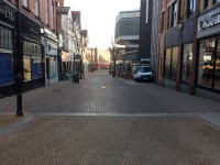
- This section is pedestrianised throughout.
- There is an easy downhill gradient throughout this section.
- The surface of the ground is concrete tiles and block paving and is uneven in places.
- Cafes in this section have outside seating out on the paved areas as part of a street cafe culture.
- Between the concrete tiles and block paving of this section are bollards at regular intervals.
- There are black refuse bins along this section.
- Much of the street furniture is painted black with gold banding.
- The Shambles is on the left after approximately 74m.
- Pump Street continues ahead for approximately 28m to the junction with New Street, Friar Street, and Charles Street (this section is shown in photograph 6).
Section 2 - Pump Street to St Swithin's Street
- The length of this section is approximately 200m.
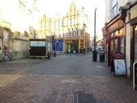
- This section is pedestrianised throughout.
- There is a very slight gradient from the sides of the street to the central gutter along this section.
- The paving is concrete tiles and block paving and is uneven in places.
- This section has benches and black refuse bins.
- Much of the street furniture is painted black with gold banding.
- There is also a red public telephone box which also contains a cashpoint.
Toilet Facilities
- Accessible and standard public toilets are not available along this route.
- Many cafes and shops have toilets but they may not be accessible.


