Access Guide
Introduction
- The following information describes the route from Granville Road (Sheffield College) Tram Stop to Bramall Lane.
- The approximate distance of the route is 1km.
- The route takes approximately 15-20 minutes.
- The majority of paths along the route consist of concrete or tarmac surfaces.
- The potential hazards on this route include; congested pathways, busy road crossings, long slight slopes and uneven surfaces.
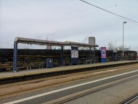
Granville Road (Sheffield College) Tram Stops
- There is step-free access to both platforms.
- Both platforms have tactile paving.
- Both platforms have clear markings on the platform edge.
- Both platforms have a shelter with bench seating.
- Both platform have information boards.
- Both platforms have digital displays for the next tram arriving.
- Both platforms have a slight slope leading to/from the platforms.
Tram stop (towards Marlin Bridge via City Centre) to Granville Road
- After exiting the tram turn left and follow the path for approximately 50m until the paths bears right onto Granville Road.
- There is a slight slope at the end of the platform leading onto Granville Street.
- Follow the path along Granville Street for approximately 35m until you reach the turning onto Granville Road.
Tram Stop towards Halfway and Herdings Park to A61 Granville Road
- There is a slight slope leading down from the platform to the pathway.
- There is step-free access along the pathway.
- The surface of the path is block paving.
- Follow the path for approximately 40m until you reach the Granville Road pedestrian crossing.
- After completing the crossing, turn left and there is another pedestrian crossing across Granville Street.
- Both pedestrian crossings have dropped kerbs with tactile paving.
- Both crossings are controlled by a signal box.
- Both crossings have a rotating cone at the base of the signal box, indicating to a visually impaired person when it is safe to cross.
- After completing the second crossing, follow the path onto Granville Road.
Granville Road to Shrewsbury Road Pedestrian Crossing
- After joining Granville Road, follow the path for approximately 70m until you reach the Shrewsbury Road pedestrian crossing.
- There is step-free access along the route.
- The path has a long, slightly downward slope.
- The surface of the path is tarmac.
- At the bottom of the path, bear right onto Shrewsbury Road and the pedestrian crossing.
Shrewsbury Road Pedestrian Crossings
- There are pedestrian crossings across Shrewsbury Road.
- Both pedestrian crossings have dropped kerbs with tactile paving on both sides.
- Both pedestrian crossings are operated by a signal control box.
- There is a rotating cone at the base of the signal control box, which indicates to a visually impaired person when it is safe to cross.
- After completing the first crossing turn left and follow the path for approximately 8m until you reach the second pedestrian crossing.
- After completing the second crossing you are on a traffic island.
- Follow the path for approximately 13m until you reach the A61 pedestrian crossing on your right.
A61 Pedestrian Crossings
- There are 2 pedestrian crossings over the A61.
- Both crossings have dropped kerbs with tactile paving on both sides.
- Both crossings are signal box controlled.
- Both crossings have a rotating cone at the base of the signal box to indicate when it is safe to cross for visually impaired people.
- After completing the first crossing turn right and follow the path on the traffic island for approximately 50m until you reach the second pedestrian crossing.
- There is step-free access along the path.
- The surface of the path is block paving.
- The second pedestrian crossing gives access from the A61 traffic island to St Mary's Road.
- After completing the crossing, turn right and follow St Mary's Road.
St Mary's Road to Shoreham Street
- After completing the crossing, turn right and follow St Mary's Road for approximately 290m until you reach Shoreham Street.
- There is step-free access along the path.
- The surface of the path is tarmac and block paving.
- There is a long slight upward slope on the path.
- The path crosses Edmund Road.
- The crossing has dropped kerbs with tactile paving on both sides and on the traffic island.
- The width of the path is restricted in places due to signposts, however the width of the path always remains over 100cm wide.
Shoreham Street to Charlotte Road
- After bearing left onto Shoreham Street from St Mary's Road, follow the path for approximately 230m until you reach the outer concourse.
- There is step-free access along the path.
- The surface of the path is tarmac.
- The path crosses the access roads to a community centre and a park.
- Both crossings have dropped kerbs without tactile paving.
- The path also crosses Clough Road.
- This crossing has a dropped kerb with tactile paving on both sides.
- After the Clough Road crossing, follow the path for approximately 50m until you reach the pedestrian crossing to the opposite side of Shoreham Street.
- The crossing has tactile paving on both sides.
- After completing the crossing, turn left and follow the path to Charlotte Road.
Charlotte Road Crossing
- There is a cycle path crossing with flush kerbs and tactile paving on both sides immediately prior to the road crossing.
- The road crossing point consists of 2 sections with a central island.
- All sections of the crossing have dropped kerbs with tactile paving.
- The road surface consists of tarmac and is mostly even.
- The road surface is cambered.
- There are no visual signals available at this crossing.
Charlotte Road Crossing to Outer Concourse
- Having crossed, bear left and continue ahead, following the path round to the right towards John Street/the outer concourse.
- There are dropped kerbs on either side of John Street giving access to the road and turnstiles.
- For access to the Tony Currie Stand and Kennedys Kop (Shoreham Street turnstiles), bear left after crossing and continue along Shoreham Street.
- For access to Kennedys Kop (John Street Turnstiles), John Street Stand, H.E. Barnes Bramall Lane Stand - Visiting Supporters, Barnes Bramall Lane Stand - Upper Tier and Bramall Lane Corner, bear right after crossing and continue along John Street.
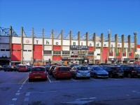
Outer Concourse (Cherry Street, Shoreham Street, John Street and Bramall Lane)
- There is step-free access along paths.
The surface of the paths is tarmac.
The path on Cherry Street crosses the access road to the Tony Currie Stand car parks.
There are 2 crossings on Cherry Street, both with dropped kerbs and tactile paving both sides.
There are long, slight slopes along Bramall Lane and Shoreham Street.
There are dropped kerbs located along the road to access the paths. - On matchdays, there is a traffic exclusion zone both before and after kick-off on the streets surrounding the stadium (Shoreham Street, Bramall Lane, Cherry Street and John Street).
- Clear directional signage is provided on the concourse.
- There is a stadium plan/map on the concourse.
- There is a steward/member of staff available for assistance on matchdays.
-
Stand(s)
View
- For more information on the John Street Stand please click here - (new tab).
- For more information on the Kennedys Kop please click here - (new tab).
- For more information on the Tony Currie South Stand please click here - (new tab).
- For more information on the Bramall Lane Corner please click here - (new tab).
- For more information on the Barnes Bramall Lane Stand - Upper Tier please click here - (new tab).
- For more information on the Barnes Bramall Lane Stand - Visiting Supporters please click here - (new tab).
- Bar(s) / Restaurant(s) View
-
Main Reception / Hospitality
View
- For more information on John Street Stand Hospitality - Reception please click here - (new tab).
- For more information on John Street Stand Hospitality - Tony Currie Suite and TV Studio please click here - (new tab).
- For more information on John Street Stand Hospitality - Executive Boxes please click here - (new tab).
- Additional Services View
Outer Concourse (Tony Currie South Stand Car Park)
- There is step-free access along the walkway.
The surface of the path is tarmac.
Caution is advised due to car park traffic.
There is a long, slight slope leading from the top of the car park to the bottom of the car park.
There are dropped kerbs from the road to the paths at the front of the stand. - Clear directional signage is provided on the concourse.
- There is a stadium plan/map on the concourse.
- There is a steward/member of staff available for assistance on matchdays.
- Stand(s) View
- Ticket Office(s) View
- Shop(s) View
- Bar(s) / Restaurant(s) View
-
Main Reception / Hospitality
View
- For more information on Tony Currie South Stand Hospitality - Reception please click here - (new tab).
- For more information on Tony Currie South Stand Hospitality - Platinum Suite please click here - (new tab).
- For more information on Tony Currie South Stand Hospitality - 1889 Directors' Lounge and Boardroom please click here - (new tab).
- Additional Services View


